There are plenty of stunning National Parks all over America and Arches National Park is just one of them. In fact, it’s one of the highlights of Utah. Arches National Park offers great landscapes of arches and incredible rock formations. There are tons of short walks, long hikes, and even a couple of canyoneering routes throughout the park that are just waiting to be explored.
Top Arches National Park Hikes
The drive along through the park is stunning, but why just drive through it when you can get up close and personal with some of the magnificent sandstone fins, famous arches, and steep canyons. The place itself might remind you of Bryce Canyon due to the sandstone and the amazing red-orange colors.
If you have a day or two to explore the park you’ll want to take a look at our list of the 14 best hikes in Arches National Park so you can decide which one needs to be explored first.
Get your Free Map of Arches National Park Hiking trails
Want a map of all the top Arches National Park Trailheads? Enter Your email and it will be sent to you!
Delicate Arch Trail

Delicate Arch is a spectacle that many visitors want to see when coming to Arches National Park. It’s Utah’s most recognizable natural arches. The trail is heavily trafficked and will take you along a partially paved path all the way to the arch, so you get to see it in all its glory. The trail to see Delicate Arch is a 4.8 km roundtrip and climbs 146m.
The trail is a steady uphill climb where you will pass Wolfe Ranch cabin and a wall of Ute Indian petroglyphs. There is no shade along this trail so make sure to bring plenty of water especially if you are hiking in the summer months. For the best views of this trail arrive early as parking is limited.
The path leading to the Lower Delicate Arch viewpoint is wide and has a hardened surface making it perfect for those in wheelchairs. From this viewpoint, you’ll be able to see Delicate Arch at the top of a distant rock wall.
Trail length: 4.8 kmDifficulty Level: ModerateElevation Gain: 146 mParking: Wolfe Ranch Parking Lot
Landscape Arch Trail

One of the world’s longest stone spans, Landscape Arch stretches an impressive 306ft (93.3m) across the sky which is longer than a football field. The arches are constantly changing and in 1991 a large section on Landscape Arch fell from the bottom of the arch. You can still see the remnants of it today.
The trail itself is relatively flat with hardpacked surfaces to walk on. There are a few moderate ups and downhills but nothing significant. The trail path changes to a sandy surface after the Landscape Arch viewpoint.
Landscape Arch is part of the Devils Garden section of Arches National Park. The trail to Landscape Arch passes through tall fins, a narrow rock wall which eventually forms the Signature Arches before opening up to reveal Landscape Arch. It’s the perfect trail for families and intrepid adventures looking for a relatively easy hike with a spectacular view at the end of it.
Trail Length: 3.1 kmDifficulty Level: EasyElevation Gain: 77mParking: Devils Garden Parking Lot
Tower Arch Trail

Tower Arch is one of the most secluded arches, hidden behind the Klondike Bluffs, in Arches National Park. The Tower Arch trail is a great way to escape the crowds and enjoy the tranquility of nature. Just under halfway between the beginning of the trail and Tower Arch is the monument known as the Marching Men. The Marching Men are a series of tall, thin towers atop the fin in rows, and have been likened to a row of soldiers standing to attention.
As this is quite a secluded route you will want to bring plenty of water and make sure you are prepared for the hike. The arch itself is large and spans 92-foot and well worth the challenge to view it. Its impressive size, presence, and depth are befitting for an Olympic Palace.
Trail Length: 4.2 kmDifficulty Level: Moderate to HardElevation Gain: 183mParking: Sandy Parking Area
Park Avenue Trail

There are no arches on the Park Avenue trail however, it showcases some of the weirdest and most wonderful rock formations Arches National Park has to offer. After passing the visitor center and climbing steeply along switchback roads, the first part of the park you’ll see is Park Avenue and the Courthouse Towers.
The Park Avenue trail can be done as an out and back or as a one-way hike from Park Avenue viewpoint to Courthouse Towers viewpoint. If you decide to do the one-way hike you’ll need to arrange transport to drop you off and pick you up. The hike to Park Avenue viewpoint is relatively flat and paved. After this viewpoint, there is a steep descent into a vast canyon. The sheer walls of the canyon often remind visitors of buildings lining a big city street.
The trail continues through the canyon and on to Courthouse Towers. Along this trail, you will get a 360-degree view of La Sal Mountains in the east and distinctive formations like Three Gossips, Sheep Rock, and The Organ.
Trail Length: 3.2 kmDifficulty Level: EasyElevation Gain: 98 mParking: Park Avenue Parking Area
Primitive Trail
Part of the Devil’s Garden, the Primitive Loop Trail is an alternative loop to or from Double O Arch. The whole loop will take roughly three to four hours and is one of the longest maintained trails in the Arches National Park.
The hike starts at the Devil’s Garden Trailhead. Along this trail, there are several spurs trails that lead off to different arches. The route along the Primitive Loop trail involves narrow ledges, uneven surfaces, and scrambling up the slick rock. This trail is not advised during the winter months due to rain or snowfall making some parts extremely dangerous.
Bring plenty of water along this trail and food to keep your energy levels up. Rock cairns mark the trail to help you find your way. About halfway along the Primitive Trail, you’ll find a spur that leads to Private Arch, the last arch you will see on this trail.
Trail Length: 12.8 kmDifficulty Level: Moderate to HardElevation Gain: UnknownParking: Devils Garden Parking Lot
Double O Arch Trail

Double O Arch is the second largest arch in the Devil’s Garden area. As its name suggests, there are 2 arches here. The first spans 71 ft and is stacked atop a smaller arch, which spans 21 ft. It’s located at the far end of the Primitive loop trail. The two arches in themselves are pretty spectacular. If you’re afraid of heights this might not be the most ideal hike for you, however, if you can put your fears aside the view will be well worth it.
The first part of this hike is flat, easy, double-wide, and heavily populated with tourists. After about a quarter-mile from Devils Garden trailhead, the trail splits into two. You’ll want to take the left-hand fork. The right-hand fork takes you on a short spur trail down to Pine Trees and Tunnel Arches. Both worth a visit.
After you pass Landscape Arch the trail becomes primitive for a short while, where it climbs over the ends of fins and is marked by rock cairns. Another quarter-mile up the trail it forks off once more. Carry on for another half a mile where you’ll find Double O Arches on a fairly rough trail. Be careful on the slick rock, especially in wet and icy weather.
Trail Length: 6.6 kmDifficulty Level: ModerateElevation Gain: 205 mParking: Devils Garden Parking Lot
Balanced Rock Loop Trail

Balanced Rock is one of the most iconic features in Arches National Park. It stands at a staggering 128ft (38m) tall. Although this formation may appear to be an epic balancing act, it’s in fact not balanced at all. The slick rock boulder of Entrada Sandstone sits attached to its pedestal of Dewey Bridge Mudstone.
Balanced Rock defies gravity, however, this won’t always be the case. Eventually, the 3,600-ton boulder will come crashing down to earth due to erosion. Unlike many of the other arches and rock formations in the national park, Balanced Rock can be seen from the park road.
The rock is located 14.8km from the Arches Visitors Center. If you want to experience this picturesque rock formation in all its glory, the best time to visit is at sunset. It’s also the perfect place for stargazing and night photography as its location is just far enough from the city lights of Moab.
Trail Length: 0.5 kmDifficulty Level: EasyElevation Gain: 17 mParking: Balanced Rock Parking Lot
Ribbon Arch Trail

This hike is best for experienced backcountry hikers as there is no established trail leading to Ribbon Arch. En route to Ribbon Arch, you will come across some nice views of Christmas Tree Arch as well as a few other less spectacular arches, which at present remain unnamed. The hike itself begins in the Windows Section by following the Primitive Trail. The hike should then take you behind North Window Arch.
This hike requires scrambling up and over some rocky shelves and boulders. You’ll also cross several canyons before coming to Ribbon Arch. Which when in view looks pretty fragile. Parking shouldn’t be an issue as not a lot of people know about Ribbon Arch as it’s not on the map the Park Service hand out.
Trail Length: 3.2kmDifficulty Level: ModerateElevation Gain: 120mParking: Windows Section
Devils Garden Trail

Devils Garden offers breathtaking views and camping opportunities as well as backpacking and hiking routes for all skill levels. It’s located right at the end of the park road, about 18 miles north of the Arches Visitor Center. The drive from the visitor center is approximately a 45-minutes. Devils Garden Campground is available via reservation from March through to October.
Along the trail, you will come across several arches such as Landscape Arch, Dark Angel, Pine Tree, and Tunnel Arch. There is truly something for everyone along this trail. Parking can be busy and is limited so you’re best to arrive early to guarantee a parking space. Devils Garden is one of the premier locations in the park.
Trail Length: 12.7kmDifficulty Level: HardElevation Gain: 331mParking: Devils Garden Trail Head
Moab Canyon Pathway

Running along the southern border of Arches National Park, the Moab Canyon Pathway offers plenty of jaw-dropping moments. The pathway follows Old Highway 191, which has been converted into a paved, off-road trail. Moab Canyon Pathway connects Moab to two national parks and one state park. The pathway isn’t just a favorite among hikers but with bikers, joggers, and runners too.
The pathway snakes through 2 miles of the red rock canyon to the entrance of Arches National Park, where you can enter and explore the many wonders the park has to offer. If you’re not feeling like entering the park you can continue on the trail as it parallels Highway 191 to the trail’s end at Highway 313. As you approach the north end of the pathway, you’ll pass the Gemini Bridges Trailhead. This trailhead sits at the beginning of a 16-mile roundtrip mountain biking and ATV trail.
Trail Length: 14.2kmDifficulty Level: ModerateElevation Gain: 266mParking: Lions Park
Elephant Butte
For this trail, you will need rock climbing equipment and knowledge. You will also need a canyoneering permit which can be purchased at the visitor center. Elephant Butte is the highest point in Arches National Park. The route winds through a maze of entrada fins and requires good route-finding abilities. It offers a great outing for canyoners with climbing and rappelling experience.
The trailhead for this route is located inside Arches National Park and can be hiked in all weather conditions. Just make sure you’re confident in your abilities and have the correct equipment for this route.
Trail Length: 2.6kmDifficulty Level: HardElevation Gain: 182mParking:
Fiery Furnace and Surprise Arch Trail

There are only two ways to enter Fiery Furnace – one is with a ranger and the other is with a day-use permit. The reason for this is because the terrain can be challenging. To enjoy this hike best it’s advised to book a ranger tour. This is for your own safety and reduces impacts on the area. Although the route is marked you could still get lost on your own.
The Fiery Furnace is a labyrinth of narrow sandstone canyons that requires agility to explore. Be prepared for extreme temperatures. During this physically demanding hike, you will climb on broken sandstone, walk along narrow ledges above drop-offs, and in loose sand. You may also need to squeeze through narrow places and jump over small gaps. Due to the challenging nature of the hike, you must be able to complete the hike once you start, you must wear good hiking boots, and no children under the age of 5 are allowed on the hike.
Trail Length: 2.7kmDifficulty Level: ModerateElevation Gain: 118mParking:
Dark Angel
The Dark Angel trail starts at Devils Garden parking area. It’s a 150-foot sandstone tower that sits a half-mile to the northwest of Double O Arch. It’s a unique formation – a great obelisk surrounded by fins, arches, and canyons. Dark Angel is located at the north end of the Arches Entrance Road. It’s a spur trail off the Primitive Loop and a sign marks the junction. You can either retrace your steps or continue on to the primitive trail.
Trail Length: 7.6kmDifficulty Level: ModerateElevation Gain: 220mParking: Devils Garden Parking Area
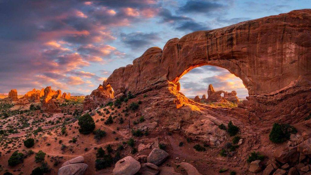
Windows Arch and Turret Arch Trail

The Windows Section is considered by some as the beating heart of Arches National Park. This area contains a large concentration of arches. It’s one of the most scenic locations in the park. A gentle climb up a gravel path leads to North and South Windows and Turret Arch. You can either take a short route and walk back the way you came or take the Primitive Loop from South Window viewpoint.
The best time to visit is early morning or late afternoon as you will avoid the crowds and the heat of the sun. There are some stairs along this trail. Turret Arch is a beautiful free-standing arch and offers a great hike for the whole family.
Trail Length: 1.9kmDifficulty Level: EasyElevation Gain: 47mParking: Windows Parking Lot
Frequently Asked Questions

What is the best hike in Arches National Park?
All the hikes in Arches National Park are worth a visit but if you only have a limited amount of time you might want to start with Delicate Arch. However, everyone who hikes Arches National Park will tell you their opinion of the best hikes. But you’ll need to visit Arches National Park yourself to decide which one is your favorite.
How long do you need to hike Arches National Park?
The length of time you spend in the Arches National Park will depend on the trail you are looking to hike. Some trails will only take you half an hour whereas other may take up to 5 hours to hike. It’s advised that you should spend at least a day in the national park if you want to explore and experience some of the natural and awe-inspiring wonders this place has to offer.
Is the hike to Arches hard?
The Arches National Park contains several hikes. All of which vary in difficulty. All the trails provide outstanding views and several arches that are not visible from the road. Depending on the hike you take will depend on how challenging and hard the hike is.
What do I need to hike in Arches National Park?
If you are looking to hike in Arches National Park you’ll want to make sure you are prepared for every eventuality. You’ll want to make sure you are wearing lightweight, loose-fitting clothing and hiking boots to make sure that you are comfortable when exploring the trails. Some other key items to take with you in a backpack are:
Sun protectionWaterproof clothingAdditional clothing in case you need to layer upBug and bear sprayFirst aid kitQuick-drying towelA head torchFood (Energy gels and bars, electrolyte tablets, snacks)Plenty of waterBinocularsHand sanitizer
This list is not extensive and there are plenty more items you could bring along with you. It just depends on the length of the hike as to what else you might need.